-
Architects: RO&AD Architecten
- Year: 2017
-
Photographs:Katja Effting
-
Manufacturers: Carl Stahl, Flax, Isovlas, RGM, Scheuten, Tata Steel

Text description provided by the architects. Pompejus is a watchtower on Fort de Roovere in Halsteren, West Brabant. The tower looks out over the West Brabant Water Defence Line, the oldest part of the Zuiderwaterlinie running from Bergen op Zoom to Grave. Pompejus is a watchtower, an open-air theatre and an information point for tourists. Pompejus is named after the first commander of the fortress, Pompejus de Roovere.

History
The West Brabantse Water Defence Line was built in 1627 by the States of Zeeland, and Zuid-Holland to protect the important shipping route from Middelburg to Dordrecht against attacks by the Spaniards and the French. The line included the cities of Bergen on
Zoom and Steenbergen and a number of forts, including the main fort, Fort de

Roovere and was the first landscape defensive work in which inundation was deployed as a defence strategy. Inundation is the submersion of the landscape so that armies can no longer pull through the landscape with their equipment. In the course of the centuries the Linie has been under fire several times, among other things against the Austrians, French and Spanish. In the beginning of the 18th century the water line became more and more important and was thoroughly strengthened by the famous fortress builder Menno van Coehoorn. Fortress the Roovere was reinforced and increased and several preliminary works were carried out. The West Brabantse Waterlinie is the only waterline in the Netherlands where ever has been battled, usually successful, sometimes not. In 1747 the line and the City fell under the siege of the French. In the 19th century the line was strategically depreciated. It disappeared in some places, in others the forts were excavated. From 2010 onwards, one has started restoring the line. Forests have been taken from the forts, canals are restored. From that time on, the line is also developed for recreation

Landscape
The line uses very subtle altitude differences in the landscape. This is possible
because it is located on the edge of the Brabantse Wal, the edge of the deck sand in Brabant. The low parts can be inundated, on the high parts and therefore defensive weak parts fortified towns and forts were built. These fortresses are sand forts and were connected to each other with ‘Linie dikes’. But also visually the forts were connected, you could look from one fortress to another. By afforestation this is no longer possible. Fort the Roovere was a central point in the landscape. The separation of fresh water and salt water inundation was here. It was the middle of the defence line, so from the fortress towards Bergen op Zoom and in the direction of Steenbergen could be looked at. This is no longer possible in the current landscape, which is why the plan came up of creating a watchtower here to make that possible again.

Design
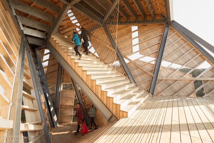
The edge of the fortress on which Pompejus stands is directed at the enemy. The tower is positioned exactly on that corner. By mirroring up the sides of the fort, a sharp shape is created which leans forward over the moat. As a result, it is closed on the outside, and open at the fort side. This creates space on the inside for an information centre and an open-air theatre for 225 people. To see the surrounding area over the trees, the tower must be 25 meters high above the fortress. Because the fortress itself rises 9 metres above the landscape, Pompejus literally towers 34 metres above his surroundings.
From the top you can look 20 kilometres far in all directions and you can see the entire West Brabant Water Defence Line.

The facade is designed according to the principle of the Voronoi diagram, a mathematical design principle in which we used the triangles of the steel construction in order to make it possible to have windows and openings in the façade. Secondly the facade can be divided into elements to be prefabricated and transported, and add an additional layer to the facade to break the dominance of the triangular steel structure.

Technology and material
In order to make the building of Pompejus manageable for everyone, we have used the File-to-Factory principle. No drawings have been made for the construction, only
a 3D model is used. This model has been directly converted into 'scripts' for a Tekla model for the steel manufacturer and in machine language for CNC milling machines of the carpentry factory. This resulted in kind of Ikea-Billy cabinet packs in which all of the produced elements were encoded and could be assembled relatively easily. These packages were also scripted in such a way that from the 3D model also automatically the assembly drawings were provided.
The construction consists of a hybrid steel-wood construction, in which the main structure consists of galvanized steel, and the sub-structure, façade elements, stairways and stairs are made of timber. The wood used is Accoya. The information space is thermally isolated and consists of timber frame construction.

Social system
In order to make this project possible, a community has grown in Bergen op Zoom who participated in the creation of Pompejus. For example, crowdfunding has been used to let people sponsor Pompejus, companies have sponsored parts of construction such as transport or wood, schools have provided interns, but also organizations have provided interns and volunteers.

People who want to use the Pompejus and fort the Roovere in the future have been active to help the development. The aim was to make Pompejus 'our tower' and to connect with the residents of the surrounding area. This has been successful not only because the tower has been built, but above all because there is already an entire organisation to program the fort with events and it will be properly programmed and managed in the coming years.


